Watershed
Geo-RIWURS (Watershed)

About Asan Watershed

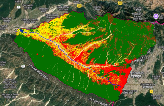
The Asan Watershed, located west of Dehradun, Uttarakhand, spans 701.15 km², with elevations ranging from 390 m to 2,218 m. The highest stream originates in the Lesser Himalayas near Mussoorie, while the Asan River begins at Chandrabani, near the Shiwalik and merges into the Yamuna. The watershed includes both urban and rural landscapes, influencing regional hydrology and ecology. Its eastern portion covers Dehradun's core city, while the western part extends into outer city areas. This watershed is vital for water supply, biodiversity, and ecological balance, playing a crucial role in sustaining both human settlements and local ecosystems.

Salient features of Asan Watershed

  • The Asan Watershed is less elongated with moderate relief, indicating a balanced distribution of runoff and sediment transport.
  • Elevations between 400m to 900m and slopes ranging from 0° to 20° are conducive to vegetation growth within the watershed.
  • Asan Watershed hosts Uttarakhand's only ramsar site, Asan Conservation Reserve, a crucial habitat for biodiversity and migratory birds.

Environmental threats in Asan Watershed

  • As per Census, between 2001 and 2011, the Asan Watershed's population grew by approximately 59%, leading to increased residential and non-residential construction.
  • Urbanisation and encroachment in the watershed are major potential causes of environmental degradation.
  • Agriculture expansion and sand mining from the Asan river bed and its surrounding areas are also major threats to the watershed.

 Asan Watershed Geoportal